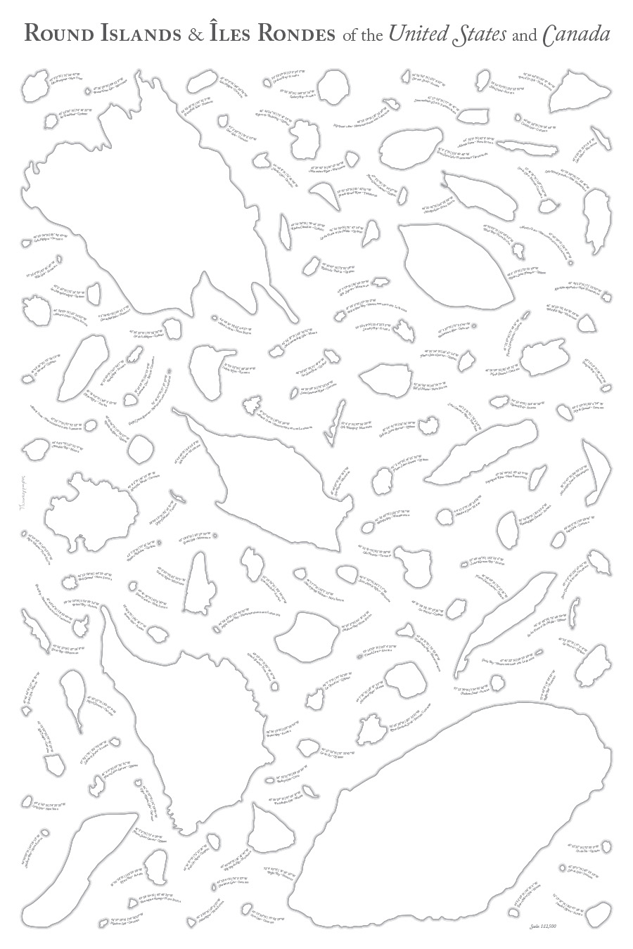
Several months ago I happened upon an island in Alaska called “Round Island.” I’d heard of other Round Islands elsewhere in the US, and I began to wonder just how many there were, and exactly how round they were. So, I decided to assemble them into a poster, for better appreciation of their numerousness and roundness (or lack thereof). I also expanded my search to include such islands in Canada, as well.

If you’re inclined, you can download a PDF.
This is an exploration of geographic forms. The forces of nature have constructed a variety of intriguing shapes, the aesthetics of which are just as important to a map’s appearance as the cartographer’s choice of color, typography, etc. I have sometimes browsed (and made) maps mainly to appreciate the particular shape of a coastline, path of a river, or some other geographic form.
I love looking at the variety and contrasts in this collection. Some of the islands are quite smooth, some are undulating and interdigitated. Some are quite round, while others are very poorly named.

This assemblage also highlights how inaccurate humans can be when naming features: many of these 131 islands are not very round. Maybe Long Island would be better for some of them. The lack of toponymic creativity is also noteworthy. In many cases, these identically named islands reside near each other within the same lake or harbor. I would be interested to see native names for these places, and whether they offer more interesting alternatives to the generic “(Sort of) Round Island.”
Each island is labeled with the coordinates of its center, as well as the body of water in which it is found.

As is usual with my side projects, I offer you some notes and observations:
- I began by grabbing data from the US Geographic Names Information System and from Canada’s CanVec 1:50,000 Toponymic Features file.
- There are a few places named “Round Island” which do not appear to be islands. Perhaps some of them were at one time, but have since been filled in. Whatever the reason, I only made use of those islands which were actually surrounded by water on all sides.

Somewhat round, but certainly not an island anymore. - I traced these islands from aerial/satellite imagery. Given that we live in a world where coastline shapefiles exist, you may fairly ask why I might spend time doing something like that. The answer is that these islands vary a lot in size and in location, and I would have had to extract them one-by-one from a variety of different data sources. In many instances, the islands were too small to either appear in easily available shapefiles, or were far too simplified. So, it was probably faster to trace them, and it left me with the level of detail needed.
- The shape and size of these islands varies based on tides. At low tide, more land may pop up out of the water. I had no consistent approach to this problem; I merely traced whatever it looked like whenever the image was taken. So, use this poster with caution if you are sailing in the vicinity of these islands. Shapefiles, I think, would not have helped much, since they’d be patched together from different scales and sources, so I would not have ended up with any consistency in approach.
- Each of these islands is actually on its own projection, thanks to ArcMap’s Data-Driven Pages. I had it kick out a PDF, with one island per page. Each page was at the same scale, and each page was in a Lambert Azimuthal Equal Area projection with the standard point at the centroid of the island.
- I did calculate the roundness of the various islands, but given the potential inconsistencies in tracing, tides, etc., I thought it best to avoid putting any such numbers on the map. I will leave it to the reader to judge just how round or not round any given island is.
- The labels (set in Adobe Caslon) are all on a curve. I like it, but I can’t really say why I was inspired to do it. My colleague Nick Lally suggested that they give a sense of the movement of water around the islands. That explanation works for me, even if I can’t claim that it’s what I originally had in mind.
- I played around with a different style for a while, involving various colors and hachures. I’m not sure why, but I initially felt like I shouldn’t make this grey. But getting the hachures to line up quite right caused me a bunch of trouble, and a highly scientific Twitter poll suggested that this style was the less-popular option. So, I decided to set them aside for now and go back to my standard grey waterlines.

This was a fun project to explore, and I hope you enjoy the fruits of my labor. Onward to the next random side project!
While I offer this project as a free PDF, it does take time and effort; if you derive some value from it, you are welcome to make a donation to support my continued work.

Simping in Borneo, could be the Smallest Island in the World
Impressive! Here’s the link to the zoomable version. Hope you find it useful.
https://srv2.zoomable.ca/viewer.php?i=img349fb4a66e0ec4a1_round-islands