This series of river maps is done up in a style inspired by urban transit maps such as those pioneered by Harry Beck in the 1930s for the London Underground. Straight lines, 45-degree angles, simple geometry. The result is more of an abstract network representation than you would find on most maps, and it’s not meant to be taken too seriously — I would not recommend actually transiting through these rivers, as many portions of them are not navigable. But they do, nonetheless, connect us.
If you’d like to know a bit more about how the maps were made, including the many many semi-arbitrary decisions that go in to them, click here.
An Atlas of North American Rivers: Free PDF
It took quite a few years to finish up, but I’m pleased to offer a free PDF covering 43 major river systems of North America.
Poster Prints
Interested in putting a river system on your wall? I’ve got a lot of print-on-demand poster options for you. Most every system from the atlas is here, plus several exclusive maps that are only available in poster form.
Click on each thumbnail to have a look, or click the link to be taken to a print on demand service. You’ll notice a few different styles, just based on how the graphics evolved over time as I kept producing/revising maps.
A Selection of North American Rivers

Southern New England

North & Central California

North America

Fraser River

Red & Arkansas Rivers

Upper Ohio
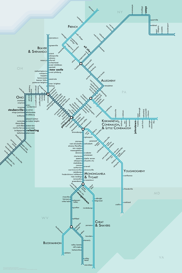
Middle Ohio

Lower Ohio

Nelson River / Lake Winnipeg

Upper St. Lawrence

Lower St. Lawrence

Lake Superior

Lake Michigan

Lakes Huron & Erie

Lake Ontario

Santee

Apalachicola & Chattahoochee

Mobile & Alabama

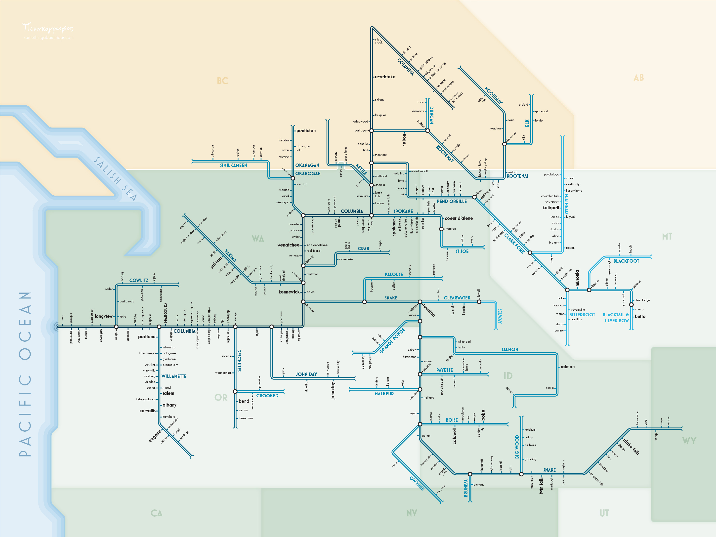
Columbia River
Chesapeake Bay

Colorado River

Michigan

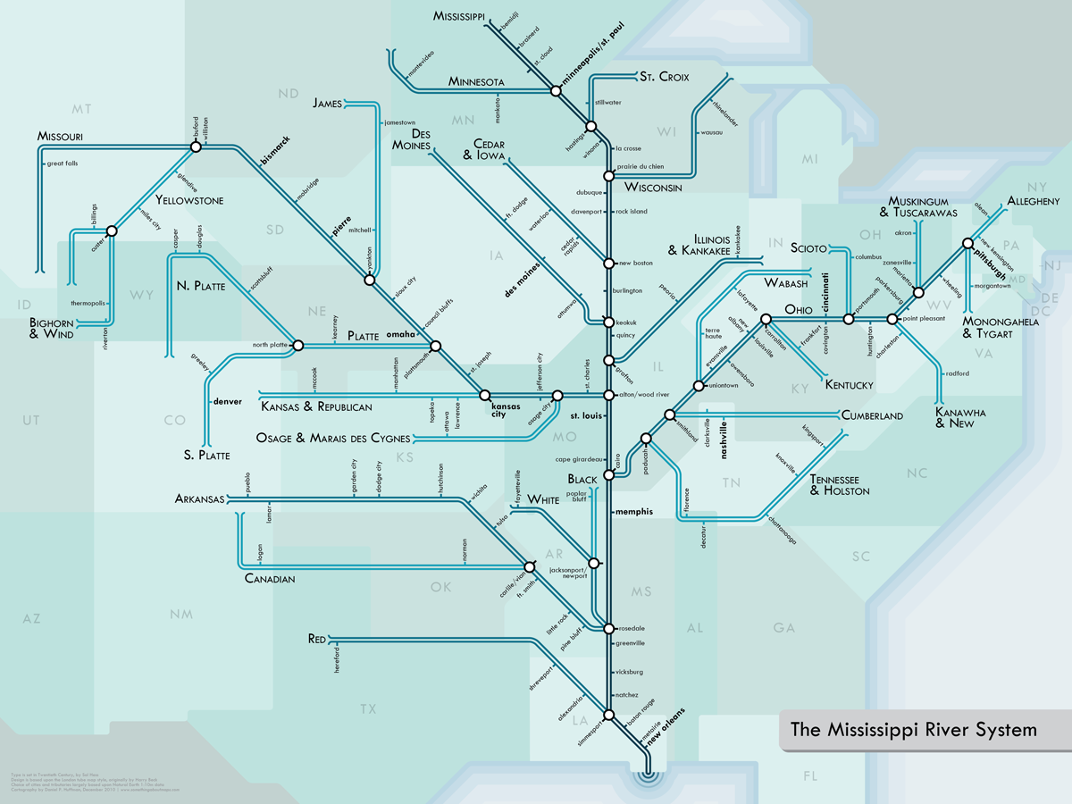
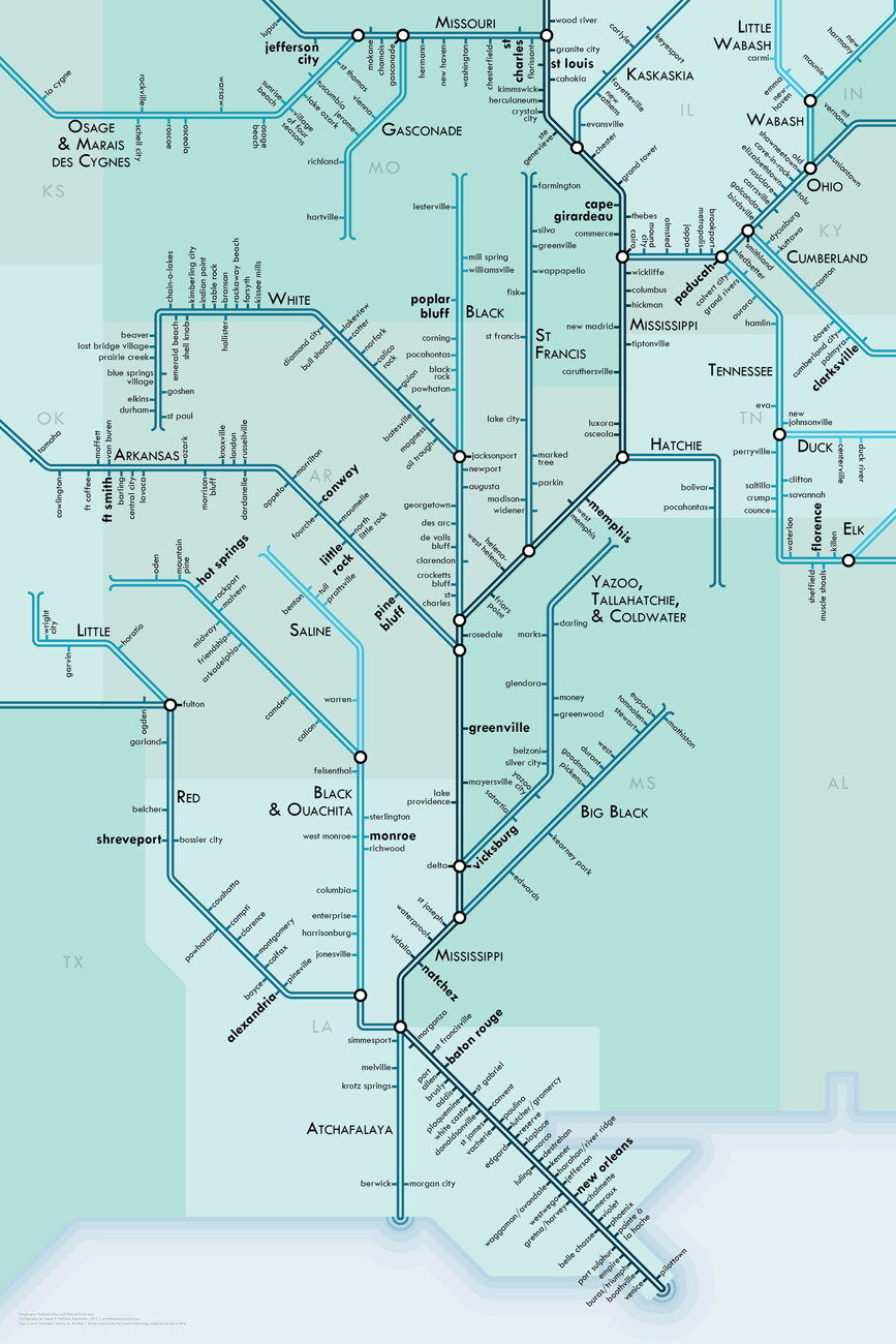
Mississippi
Upper Missouri

Lower Missouri

Yukon

Mackenzie

Tennessee & Cumberland

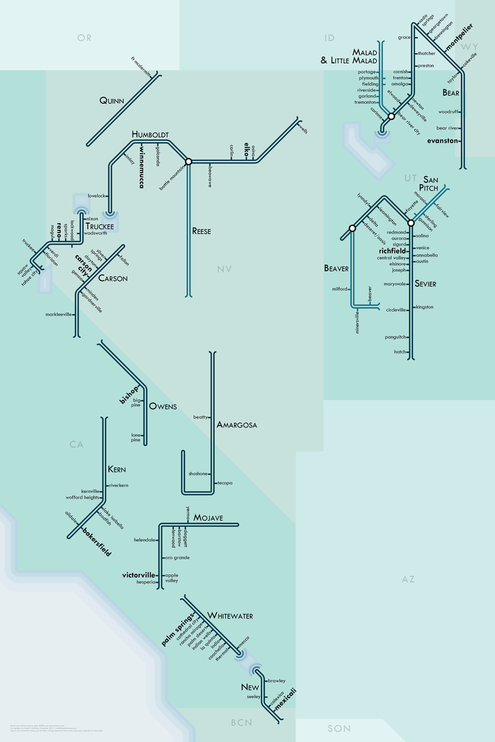
Great Basin
Upper Mississippi
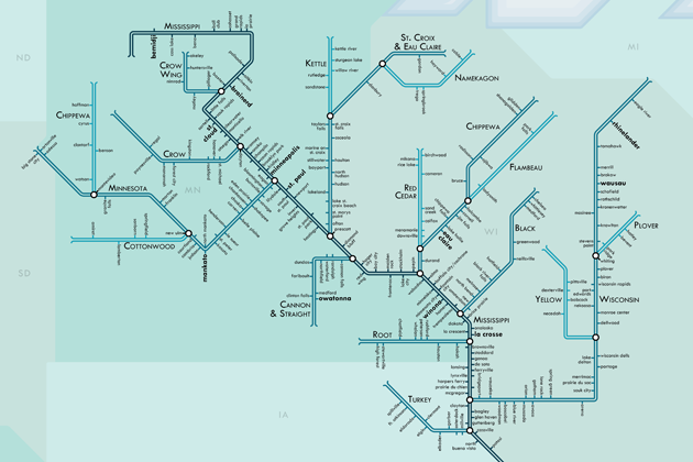
Middle Mississippi

Lower Mississippi
Rio Grande

Hudson

Connecticut

Gulf of Maine

Brazos & Colorado

Río Grande de Santiago & Lerma

Grijalva & Cuilco

While I offer most of these maps as free PDFs, they do take time and effort; if you derive some value from them, you are welcome to make a donation to support my continued work.

Columbia River watershed next?
I second the request for a Columbia River Map! I LOVE your art. Thanks for sharing!
Me three!
These are beautiful! I would love to have one of the Columbia.
Yeah for Columbia
Chesapeake next!!?? SWEET !
That would b awesome! Great idea.., largest fresh water sanctuary in the U.S.
Are you interested in corrections? The Clark Fork branch of the Columbia has a couple with regard to names. I’m surprised you left off the large natural lakes such as Flathead and the four major tributaries above it. I also note the entire Clearwater drainage coming into the Blackfoot from the north is missing.
Hi Dan,
Corrections are welcome. I have lived with the fear for weeks now that I have made grievous errors that would not be found out until someone had already given me money, leading to angry demands for refunds.
I’ve mostly kept lakes off as a stylistic choice based on personal preferences (unless they’re the Great Lakes).
As to the choice of tributaries, I have left that to my data source, which is Natural Earth (naturalearthdata.com). They make their decisions of which streams to show based on a combination of rainfall models & stream gauges (where most of the actual water is travelling) and tradition (what has traditionally been shown and been considered regionally important). I also use them to get the name data (supplemented by the National Atlas). I can pass along corrections you may have to them, as well, so that these errors will not be propagated on the maps of others.
You missed the Atchafalaya river, which is a major distributary of the Mississippi. The Atchafalaya takes about 1/3 of the total Mississippi River water (a ratio maintained by the US ACE). The Red River empties into that, and the the whole Atchafalaya enters into the Gulf of Mexico into Atchafalaya Bay, far to the west of the Mississippi River Delta.
Have you thought about doing this for the Thames watershed? Given your design is based on the Subway design for London I think it would be very popular.
I have indeed. However, that might need to wait a while. I’ve recently completed (but not yet published) an atlas of North American river systems, and I think, after 18 months of doing these, I might need a bit of a break =). But, if I return to this style again in the future, I expect to focus more on rivers on the other side of the Atlantic.
>________________________________
I’d buy one of the colorado…
That’s actually near the top of my list, so I’ll let you know if I get one together soon.
Please! I would buy several of the Colorado Basin
Done! See above for detail images and a link to purchase, if you like it.
I put one together this weekend and it’s up for sale now. I have images here:https://somethingaboutmaps.wordpress.com/river-maps/
Potomac River please!
Ever considered doing one of Britain’s canal system? Or maybe you know someone who already has?
I’m not aware of one at the moment, and, in fact, I must admit to ignorance of the subject. Might have to do some studying up. The original idea behind the river map series, a couple of years back, was actually to show the various canals constructed in the early United States, emphasizing their importance by showing how they connected different major river transit networks. But I haven’t yet got around to doing the research, and I ended up just showing natural river courses for now as a sort of proof of concept.
I would like to buy one of these (the Southwest New England system) and have it displayed on canvas (using another website service that will print photos onto a canvas frame – this is NOT an ad for them!) to do this, though, I’d need to send them an electronic version of the map. Is there any feasible way to make this happen?
These are great, I am a geography teacher, map geek and a kayaker. I live on the banks of the Rhine in Switzerland and would love a map of the Rhine drainage basin from the Alps to the Netherlands. I’m sure you’d sell loads of the as so many people live along the Rhine.
These are great, I am a geography teacher, map geek and a kayaker. I live on the banks of the Rhine in Switzerland and would love a map of the Rhine drainage basin from the Alps to the Netherlands. I’m sure you’d sell loads of them as so many people live along the Rhine.
Here’s hoping
James
Er seems to have posted twice, sorry,
James B, a different James to the one who posted below
Love the Mississippi map – never new tributaries reached as far as NY.
Was going to suggest some UK rivers, but would actulaly second lloyds suggestion of the fascinating UK canal network…
How about the Chesapeake watershed? So many great river names; “Chickahominy,” “North Fork South Branch Potomac,” “Mattaponi” (formed by the merging of the Ma, Ta, Po, and Ni, naturally)
Mat*, Ta, Po, and Ni.
Agreed. Chesapeake would be awesome….
Yeah, definitely a Chesapeake one…with its numerous big, famous tributaries (Susquehanna, Potomac, James), it’s like the Mississippi for us Eastern Seaboarders. Maybe you can put the Delaware and Hudson on there too, and have all of the bad-ass super-old rivers that slice through the Appalachians.
Yeah! Another vote for the Chesapeake watershed.
These are awesome, Daniel. I came across them randomly and was pleasantly surprised to see that you had done them. Our cohort has done well.
Nate
I really like your maps but I am surprised of the large number of very important rivers you left off the Columbine river system. I think you are looking at this from a navigation stand point and not a fishing stand point, which is far more important here in Washington and oregon. I also think adding dam locations would be a great idea. The Columbine river system has close to 50? dams. the columbian can not be traveled its length with out a trailer to hull out around many dams. you can however navigate up the snake pass several dams.
Hi Tom,
I’m not actually approaching this from a standpoint of navigation but of examining the entire hydrological network. The data set I draw on for my steam paths generalizes them according to their importance to the system — things like what streams drain the biggest areas and which provide the bulk of the water flow. Adding the settlements is a way to give people a bit of location context so that people realize where these rivers are in relation to the built environment. It will hopefully also remind people of the relationship between human and nature, since these streams can provide drinking water or irrigate fields or become polluted even if they’re not navigable. You are completely right, though, in that something like fishing and other recreational activities would be a great thing to consider as well when deciding what streams to include. For that I would need a guide to tell me which are best for that sort of thing, as I am not a fisherman. That would also be part of another project, since I’d need to find the room to fit all those extra features on the map =).
Thanks for the suggestion!
I would love a California-wide one, or at least one for SoCal. We have plenty of rivers down here, even if they often have no water!
Love the focus on rivers – these maps spur interesting conversations. And thanks for supporting river conservation!
I love the concept and the execution, both! but I’m puzzled as to why the Yuba River (north and south forks) isn’t on the North/Central California map. I’d buy one that included those! And thanks for supporting river and watershed conservation <3.
Hi Andrea,
Thanks for the kind words. Unfortunately, some streams must necessarily be cut due to a shortage of space. I drew on the Natural Earth data set (naturalearthdata.com) for making the California map (and a couple of the other ones). The people who made it whittled down the streams for the region into what they believed were the most critical ones to portray. If I were to re-do this map at a bigger size I would probably go in and add a bunch more! I hope you’re not terribly offended by the omission.
What I think is more striking is that a map of norcal skips San Francisco. Clearly justified in this case–there are no rivers there. In this context, it’s a bit player next to Salinas and Sacramento!
These maps are really cool. I would love to see the California map to include features like the Yolo Bypass (perhaps drawn as a 4 track section) and the state water projects since these canals move as much water as many of the natural rivers shown.
I love the Colorado River map, but it needs the dams marked on it. Why just Parker Dam–a relatively minor dam–and none of the big ones. Also it would be nice to have the major canals that drain the water out of the river.
Hi Brad,
Actually, I was not marking the dam, per se, but the settlement nearby named Parker Dam. But, I can understand the confusion. As to dams generally, and canals, I think I would prefer those as another project, more about how we’ve affected the landscape than about the natural watercourses, and probably in another style entirely.
Cheers, Daniel
Daniel,
Actually the settlement of Parker Dam is a ghost town as it was torn down several years ago. The present inhabitants are some wild burros, and two coyotes. The dam itself has the distinction of being called the ‘world’s deepest dam’.
I know the area extremely well. Have fed the burros and chased off the coyotes numerous times.
Dave
Dave,
Thanks for the information. Perhaps the folks at Google are out of date? They show a street network and a few businesses in the area. Weird.
The Great Basin would be a neat addition to this collection. I know it’s not the largest watershed in the world, but it’d be neat seeing a bunch of rivers “terminating” subway-style in the same depression.
Excellent work Daniel!
A very effective for visual tool for showing the relationship of settlements to the river sytem. I do think a version with major dams would be great!
I plan to order posters of the Columbia and North & Central California but wonder if you’ve considered selling high-resolution images of your work.
Hi Van, Thanks for the kind words. I think I am not entirely understanding your purpose with the high-res images. I certainly could sell people the original vector files or high-res rasters of them, but I suppose I hadn’t thought that anyone would have any use for them.
Sorry I was unclear. Simply to be able to plot our own posters for those that have access to a plotter. A high-res .pdf would work for that.
It would indeed. If you send me an email, I would be willing to work something out with you if you’re interested in obtaining a PDF.
Cool stuff — I’ve just come over from “Strange Maps”.
You already have lots of neat request ideas, but have you thought of doing more than a river? I’m thinking specifically of the Chesapeake Bay watershed — I saw a poster of it recently, and it’s surprising how far north and east it goes. I can imagine the “transit-map”-like scheme might be a bit fine-grained on the eastern side of the bay, but the west side would be pretty interesting.
I have, in fact, been musing over the Chesapeake Bay lately, so it might be a good option for the next one. I hadn’t really looked into its size until just now — I, too, am surprised to find out that it goes up into New York!
Absolutely love these maps and want to sew them up as wallhangings immediately! They’re inspiring all kinds of ideas, too many at once. Had a map of British canals in my summerhouse when I was 10 years old. Maybe British Waterways have it – for LLoyd’s comment above. There are library books in UK on that subject.
Thanks again for these.
I was very pleased to see my hometown (Decatur, AL, which is nicknamed “The River City”) on the map of the Mississippi system. Thanks for making these!
As for suggestions, I’d love to see the Hudson River basin—that would take care of all the rivers I’ve lived on! (You’ve already got the Tennessee and the Charles.)
How about the Hudson River?
Awesome Maps. Please add the Tennesse-Tombigbee to the Mississippi map. You cant cruise the Grand Loop without it. Pluss the Port of Mobile is growing by leaps and bounds now that heavy industry is headed southwards.
Really cool! I love the idea, representing natural features in ways we normally “reserve” for more artificial infrastructure systems.
Curious as to why you didn’t include the Cape Cod Canal in your New England map? Granted, not a “river” or “stream” but a pretty significant body of water.
Thanks for the post, I enjoyed perusing!
Hi Yuki,
You are quite right in that it’s an important artery. However, I was primarily focused on the natural world, and also of rivers which were of sufficient length to include. I had to find a way to filter down all the very many rivers in the area, and I went by length as a way to help keep things simple — I think I set a criterion of something like 50 miles in length to be considered as one of the main streams, and about 30 miles for tributaries (don’t quote me on those numbers exactly).
very cool. i’d definitely buy the schuylkill and delaware watersheds (around philly), if you’re thinking of adding more.
I second the request for the Schuylkill. Would definitely buy that. The Schuylkill River Trail (100+ miles for cycling/walking) will be completed soon and you may have a marketing opp there.
I, too, would be interested in a Delaware Bay watershed map (w/ Schuylkill, Perkiomen, Neshaminy, Lehigh, Musconetcong, etc). I gave my brother the Chesapeake Bay one framed as a wedding gift and also had one framed for myself…the Delaware would be a great companion piece.
I saw the Chesapeake at a friend’s house and loved it. I would love a Delaware Bay watershed; I’m an estuarine ecologist and work with lots of others and we’d all be excited about it!
Thanks for the kind words. I’m working slowly on wrapping up the existing maps (checking them for errors, etc.), but I think the Delaware Bay would be first on my list of new ones to make once the time comes.
As a map geek, color me officially impressed! It might be interesting to see the major canals built off of the Colorado system on a future version. And of course, the Owens River now flows directly into my apartment’s sinks and showers via the Los Angeles Aqueduct!
Hi Adam. Thanks for the kind words. I learned a lot about how little “nature” there was left in some of California’s rivers when making this map, with the Kern and Owens.
Cool Work, but the Mississippi does not meet the Red at Shreveport, it meets at Baton Rouge.
I think you may be mis-reading the small type on the image I put up — the junction of the Red and Mississippi is marked as Simmesport, which is a little hamlet a few miles away from the junction (and the only civilization for miles around, as far as I could tell). Baton Rouge is a little bit down the line.
How about the Chesapeake Bay and associated watershed that has a northern start in PA? Largest freshwater estuary in the U.S.
These are amazing. Really put rivers in a new perspective!
Are you interested in other continents? The Rine, Danube and Volga spring to mind as major cultural hubs…
Hi Reena. I have been thinking about shifting away from the US soon and into other lands. The Rhine sounds to me like it may be a good starting point.
any chance of getting the colorado river that runs through texas?
Very cool! as for next obes, Ob Irtysh , Nile and Amazon would be interesting
These are great maps! It’s been a long time since someone put some real thought into the aesthetic of river mapping. My work is in the same, more on the functional side of the representation, but these are just as functional as artistic! Your California map reminds me of a full Sacramento River Valley map that a researcher from UC once presented, looked just like yours but with a lot more microscopic engineering detail, and I’ve seen the USBR map of the Lower Colorado in a similar aesthetic, so you’re not ranging too far from the new norm for engineering of riverways.
I would love a version for all of NE, especially including the Maine rivers: Kennebec, Dead and Penobscot that I have rafted for many years.
When I choose a 30×40 print and go to the zazzle store, none of the size options match up exactly. Which is the best size if I want to avoid scaling/shrinking issues?
There’s a weird oddity of the way Zazzle works in that it won’t tell you the real size of the print. If you click on the 30 x 40, Zazzle will call it something larger than that…but, that’s because they have to print it on a sheet of paper that’s larger than 30×40, then cut it down. Your final product will be the size that it says in the item title.
Hope that helps! I’ve got explanations scattered around explaining the problem, but I should put one in a more prominent place.
Okay that’s what I thought but I just wanted to make sure. Thanks!
if you had done the rio grande i would have definitely bought one. it would have been neat to see a transborder map.
Gorgeous, well-done! Chesapeake watershed would go on my wall immediately if you do that.
As a graphics design and map lover, I hope this is leading to a book. While I will content myself with the low resolution snippets, I will buy the book as soon as it shows up somewhere!
Your comment has already sent my head spinning with ideas for an atlas. I’ve always wanted to make an atlas…
Fantastic Map!
These are amazing! I love rivers and maps. Not to burden you with suggestions, but have you considered the Yukon river in Alaska/Yukon Territories/British Columbia? It is my current favorite river system.
Hi Rebecca,
Thanks for the kind words — I think the Yukon would be a great addition. Long may it reign as your favorite =).
Very interesting, but with one big flaw from my admittedly local angle: In the name of simplification it depicts the Iowa-Cedar system as one river. This places my home in Iowa City, on the Iowa, downstream from Cedar Rapids, which is on the Cedar. The two rivers meet below both cities, at Columbus Junction.
This point of confusion buffaloed all my out of state family and friends during June 2008, who watched the flood crest at Cedar Rapids and assumed that we getting that crest, when in fact the flooding on the Iowa was a bit less bad.
Hi John,
Thanks for pointing out the correction. I am embarrassed to say that I simply mis-read the base map that I used to construct my work. The actual line I was attempting to depict was the Cedar, then the Iowa below Columbus Junction — those two lengths together form the main channel which carries much of the water in that area. So, properly, Iowa City should not be on the map at all, since it’s on the portion of the Iowa which isn’t included because it’s hydrologically a bit less critical. But, I got a bit lost when reading my basemap and stuck it on cedar accidentally, as it was close enough by to make the mistake. I’ve uploaded a new version without Iowa city, which hopefully is a bit more accurate now. If you happened to have ordered a print, let me know and I’ll replace it (and I need to see about getting in touch with Zazzle to see if they have a system for me to contact previous purchasers for the same purpose).
I’ve often wondered why it’s called the “Iowa” below Columbus Junction when the Cedar is the larger river at the intersection.
While I am seriously considering purchasing the Mississippi River Map, I have to point out that Metairie, the largest suburb of New Orleans, is located not on the River, but on Lake Pontchartrain. Other communities of Jefferson Parish, LA, namely Kenner, River Ridge, Harrahan, and Jefferson, lie between Metairie and the Mississippi River.
Hi Louis,
Your point is well taken. At this scale of map, a lot of smaller communities have to fall off (at some of the smaller-scale maps, like the Colorado, on the other hand, I tried to include every little hamlet I could find). Metairie is very close to the the river, and is a major settlement, and so I had to make a hard choice about how to portray it vs. its smaller, less recognizable, but more on-the-river neighbors. I hope that you will take no offense at the choice.
This is really, really beautiful. I’ll second a vote for Amazon, Nile and Mekong.
…I wonder if the American Museum of Natural History would be interested in selling these?
What, no love for the Clinton?
Lovely maps, despite hurting my Pontiac pride. ;)
I’m a big fan of the Mississippi River System map. I’d buy a print immediately if not for the omission of the Rock River, which feeds in from Illinois at Rock Island/Davenport. It’s the juncture of the Mississippi where the river runs East-to-West for 20 miles before bending back south, another geographical feature I wish were documented here.
Otherwise, brilliant work.
Wonderful. Love the Mississippi & Columbia – having spent time in Upstream watershed of both.
An east coast map of Chesapeake (Susquehanna?), Delaware & Hudson would be great if you can get it all in one place.
Mac
Can we get these graphics on a T-shirt?? (h/t to Strange Maps for sending me your way)
An interesting notion. Zazzle does T-shirts, and it’s a simple enough matter to port the map image over to the front of one of those. I’ve never ordered one from them, so I can’t say as to how well it will print (though the design is pretty robust, so it should be fine), but I would be happy to set one up if you’d like to try ordering one. Do you have a map (or section of a map) in mind?
Here’s a suggestion for something completely different: how about a map of the Great Basin, showing all the rivers with almost no network whatsoever?
These are absolutely fantastic! Do you have any thoughts on whether these would look better in matte or glossy finish? I’m getting the Columbia for my office.
Hi Michael,
Thanks for the kind words. I personally prefer a bit of gloss to mine, though I suppose it might depend on the lighting you have in your office (you don’t want it to catch a lot of glare). I think the design works pretty well, either way. It is probably mostly a matter of personal preference.
Beautiful and brilliant work. Thanks.
If you are taking requests, the Potomac River in DC and the other tributaries of the Cheasapeake Bay would be wonderful.
This is some really great work. I can see the love you put into it by how difficult it was for you to determine what should stay and what needs to be left out. I think you did a great job balancing accuracy with visual appeal.
I’d love to learn how to do this with the ArcMap software you mentioned. Can you point me in the right direction of any good tutorials or first steps I could take to learn more about this?
Thanks…and I second the votes for the Amazon and the Nile, as well as the many other geographically significant rivers around the world.
Hi Colin,
Thank you for the kind words. Actually, very little of the work I do is in ArcMap. I use ArcMap to basically throw together a base map — a quick image of states, towns, and rivers that looks terrible but gives me an idea where they are. I then draw everything out manually in Illustrator while looking at the basemap as a guide. If you look at many of the images in my other post on the subject ( https://somethingaboutmaps.wordpress.com/2011/01/28/on-river-maps/), you can see the base map that I was tracing off of. That’s what I use ArcMap for – making a quick visualization before I begin to even make the actual map.
Cheers,
Daniel
I would love to see a map of the Lake Champlain (intersection of NY, VT, and Quebec) watershed.
Could you do one of Minnesota? Northeastern Minnesota? I’d be ever so grateful!
I love the idea, but know that the Klickitat should be on the North before Lyle, for the Columbia River System. It seems there is more attention to the towns than the actual aquatic inputs. You need to decide what you want to depict, because the Klickitat River is large enough that it should not be ignored.
Hi Richard,
Thanks for the kind words. All maps require generalization, and there are probably many people who would disagree with some of the choices I have made, as everyone would likely do things differently. The “should” of a map is determined only by its final purpose; mine are purely personal projects and therefore need only satisfy me and anyone who might wish to purchase one. I am always open to hear suggestions (the maps above were built with the input of many colleagues), but I cannot always enact them. I am sorry that I have given you the impression that I did not decide what I wanted to depict, as I have taken pains to be deliberate throughout.
If you happened to have purchased a print, please let me know and I will refund you.
These are great! I love to see a map of the Alabama River, Tennessee-Tombigbee Waterway, TN River.
I second the Alabama vote. I doubt there’s much of a market, but I’d be interested.
These are awesome- I grew up canoeing many of the rivers in Michigan. Something that would be pretty cool would be to have a “transfer” connecting the Ausable and the Manistee. If you look on a real map, the two rivers are only a few miles apart in Crawford County. Fur traders and Native Americans took advantage of this, and portaged between the rivers, cutting the distrance traveled about in two, and also greatly increasing safety. There are still folks who make use of the portage, as you can see in this tour, which has a long (outer) or short (inner) passage options. You can see details here: https://sites.google.com/site/vkmchallenge/adventure-details
Hi there! These are fabulous – I’m especially fond of the southern New England map. I would love to see maps for northern New England (especially VT, NH) and upstate NY. (I work in New England & New York rivers, and I would love to fill my office with these maps!)
Oh man, this is really neat. I’d love to see you do the Chesapeake Bay watershed at some point.
yes yes yes Please do Chesapeake next — maybe with the Delaware thrown in too, since the Delaware doesn’t have that many tributaries, plus its headwaters and the Susquehanna’s are only a few miles apart in upstate New York…then you’ve basically got the Mid-Atlantic covered.
Hi. Great maps! Do the Nelson River next!
Great idea. Please do the Potomac/James/Rappahannock drainages next. All sorts of interesting features: dendritic and trellis patterns, not to mention stream capture and superimposed drainage! I also like the suggestion of doing the basin-and-range region.
Hi Daniel,
These are great! Have you considered eventually combining the major river systems into a larger map — color coding each system differently to resemble different subway/metro lines? You could even add man-made connections between different systems (as with subway connections between different lines that approach each other but don’t share tracks)
Hi Gerry,
The thought has crossed my mind, to be sure. I’m working on some other river-related projects at the moment, but it’s something I’ve been keeping in mind for the future. You’ll hear about it here when it’s ready.
Great idea for maps. They are really beautiful. I work with a geologist who said the Spokane River is missing.
Actually he just sent me this “It is the name of the river that is missing – the Snake is named after all the other join to make it; but not the Spokane.”
How about one for the State of Vermont? or maybe Vermont, NH and Maine? I’d buy one of those for sure. Thanks! love your work.
As a Texan in the UK I really like your “Tube style” maps! What a great approach and I can easily see why your maps would make great learning tools in schools and fun art in an office!
Would you consider making one for the Trinity River in Texas? Or for the main river networks in Texas?
I would indeed. I’m currently working on putting together an atlas, actually, covering much of North America. As individual spreads are completed, I’m hoping to make them available as posters. However, it’s going to take me a good year or two, probably to get through everything. Not sure when I will make it to Texas. But I’ll let you know when I do.
Cheers,
Daniel
daniel please fast forward to texas now…muchas gracias.
Love the maps. I am a hydrologist in New England and I think several of my colleagues and I would be interested in a map of all of New England! Thanks.
I love your maps. I’ve always been interested in “alternative” and more useful ways of presenting information.
How about the Puget Sound watershed (i.e. the Seattle area), including the Snohomish, Snoqualmie, Skykomish and Skagit rivers)? With all the outdoors-people in western Washington, I have a hunch there would be a pretty good demand…
Great work!
The Adirondacks in NY would be very interesting –
The Adirondack dome collects water and sends it off in all directions — west to Lake Ontario, north to the St Lawrence, east to Lake Champlain, and south to the Mohawk and Hudson Rivers.
The rivers there were the entry way into the mountains for centuries, so almost every town in the Adirondack Park is on a river or lake.
best regards,
-Thatcher
These maps are great! I would like to buy the Nelson River map, but one important piece is missing: the Churchill River diversion, through which most of the water from the Churchill River is diverted into the Burntwood River. What’s you opinion on including major diversions? Smaller navigation canals are a different issue, but when most of the water is diverted (like in this case), it would seem appropriate to include diversions.
Thanks for the kind words. I think you may be the first person to ask about this. It’s something I spent a while grappling with — whether or not to show artificial flows such as diversions and canals and the like. I’ve decided to keep the series focused on natural flows, in the end, before human intervention. It’s very much a matter of personal preference — including such large diversions would certainly be an appropriate direction to take this project, or most other river projects. But it’s just not where I felt like going right now. It’s an interesting, and very educational, challenge for me to understand the landscape as it was before so much was done to reshape it.
Thanks for the comment, and I hope that you will not look too unkindly on my work on account of these omissions =). I appreciate your asking my opinion on the matter, rather than immediately accusing me of doing it wrong, which sadly seems to be the way with a number of commenters.
>________________________________
According to this paper on major diversions in North American, the Churchil River diversion accounts for 70% of all interbasin water transfers (in terms of volume of water):
Click to access InterbasinWhitePaper06.pdf
Hi, I posted my second comment before reading your reply. I think focusing on natural flow provides a good starting point for a discussion on how much we are changing the landscape. I hope you eventually get to make a second series showing canals and diversions. I am willing to help for Canada.
By the way, I think I found a typo on your Nelson River map: on the Qu’Appelle River, “sand point beacht” should be “sand point beach”. This is an interesting subway stop: you’ll find mostly cottages there, on the shores of beautiful Buffalo Pound Lake which essentially exists because of water diverted from the South Saskatchewan River to the Qu’Appelle River in order to provide drinking water to Regina and Moose Jaw. So diversions have contributed to many of the “subway stops” found on your maps.
Thanks for the note. I check everything thrice before posting it, but sometimes errors still slip through. It’s hard to edit one’s own work with fresh eyes. I’ll fix that this evening.
It’s quite true that a lot of these settlements exist because of the changes to the landscape, and that is a certain inconsistency between the way I treat the rivers and the settlements. I can’t say as I can provide an elaborate artistic justification for it. It’s a mix of time periods and constructed and natural features, to be sure.
>________________________________
May I use your map on a slide that I am building for a presentation? I teach intelligence analysts how to present complex data sets to decision makers. Your graphic is a prime example of what I try to convey. This concept could be utilized by people conducting humanitarian operations in support of natural disasters. I would like to share your material with the NATO leadership that I train on a monthly basis; I will include your contact details within the graphic if you wish. I can be reached directly at rees5@hotmail.com.
Please feel free to use my work for your presentation. I have released the PDFs of my river maps with a Creative Commons BY-NC-SA license, which you can read more about here:�http://creativecommons.org/licenses/by-nc-sa/3.0/
Let me know if you have any questions!
>________________________________
i, too, would love to see a map that includes the Hudson River and various waters around New York.
Thanks for some other informative site. Where else may I get that type of info
written in such a perfect method? I have a
undertaking that I am just now working on, and I have been
at the glance out for such info.
Hi Daniel,
What an amazing set of map – I’ve really enjoyed examining each of them. I’m slightly disappointed (and likely biased) that you didn’t include any rivers found in the south! Georgia has some amazing rivers, the Chattahoochee, the Altamaha, the Chattooga. This doesn’t even include North Carolina or Tennessee! Thoughts on expanding to the southeast?
Looking forward to what’s to come!
Hi Sarah,
Thanks for the kind words. I’ve actually completed a few maps for rivers in the South, but I haven’t actually put them up here yet! It’s on my ever-lengthening to do list. I have all the content for my rivers atlas ready, I just need to get around to compiling it.
>________________________________
Addendum: I’ve put a few of those up now — the Apalachicola/Chattahoochee, the Mobile/Alabama, and the Santee. Hope you enjoy!
Thank you! These are awesome and there’s now some love for the south! I look forward to seeing what else you’ve got stored away!
Thanks again – Sarah
Can you finish out the Chesapeake to include the Delmarva Peninsula? These would make great gifts for our office!!!
Hi there, every time i used to check website posts here early in
the morning, since i like to learn more and more.
In the Columbia river map: it’s spelled Okanagan, not Okanogan.
There’s actually a difference in spelling between the Canadian and US portions of the river. I picked the US one, since it spends a bit more time there. (Likewise, the Kootenay in Canada is called the Kootenai in the US, but it’s mostly in Canada, so I went with the former spelling).
One minor tweak on the Columbia River map: the Okanagan River is what’s north of the 49th and the Okanogan is south of it. We Canadians like to spell things differently from y’all.
Nice Maps!!
A map of the rivers in the Adirondack Park/Mountains of New York State could be very interesting, since the area is a huge dome with rivers coming off in all directions and emptying into the Hudson River, Lake Champlain, the Mohawk and the St. Lawrence.
Love it.
I would love to see the same for the Murray, Darling, Murrumbidgee, Goulburn complex in Australia
You missed Esopus Creek in the Hudson drainage.
I’m sorry to be negative, but I find this mapping exercise arrogantly anthropocentric, and actually disrespectful of rivers. I appreciate good graphic design, and consider myself a designer, but as an ecologist, I find the reduction of an infinitely complex natural system to a completely human engineering diagram deeply disturbing.
Hello Mark,
You make a very important point which I have been meaning to address in a blog post for some time: all mapping is an exercise in sin. We cannot depict anything spatial without unfairly abstracting it. These stream systems are exceedingly complex, but so is a city, a road network, or a population. That black dot which we put on a map and label “Chicago” is a gross simplification of a living entity with millions of people, each of whom has complex relationships and hopes and dreams and education levels and income taxes, etc. etc. A map simply cannot capture everything, or even most things, at a time, and I believe that is the tradeoff we must make: in order to simplify things to the point where we can actually communicate and understand what’s going on, we must leave things out. To my mind, it’s really the point of mapmaking, or other info design. The real world is too messy to understand all at once, and we need to approach it a piece at a time, and build up the whole picture.
As to the anthropocentrism, that was intentional. One of the stated goals of the project, above, is to depict the natural world in a more artificial, constructed language, which is something we don’t see every day. It a shift in perspective, and maybe to one that’s offensive to some, but I think that in and of itself is interesting to ponder. I had not anticipated a reaction such as yours, and while I’m sorry to have annoyed you with the project, I find the outcome to be enlightening.
I did not miss Esopus Creek. I deliberately excluded it, as I did hundreds, if not thousands, of other drainages in each system. Just like every map or other representation must exclude complexity. If you open almost any atlas, you will find rivers that someone “missed.” I must admit that I find your first statement very unfair and perhaps arrogant: I feel like you assumed that I failed, and that you knew better than I, but you did not account for the fact that I may have made a reasoned choice. Mine was simply different than the one you might make. We can debate the merits of our choices, certainly.
OK.
I’m pretty sure I did leave my gmail address.
Sorry to assume that you missed the Esopus, that was, indeed, arrogant on my part.
I suppose just dont get the project. I really enjoy maps when, through the simplification they represent, unrecognized relationships are revealed. I think a standard U.S.G.S topo or DOT planimetric map reveals the longitudinal relationships between urbanized areas nicely, and I’m not sure what is added, except in the interests of graphic design, by abstracting the river/urban network to subway map symbolization.
I think our society is sick with its alienation from natural systems. If your project brings some overly urbanized people to awareness of natural rivers, that’s a good thing.
good luck,
Mark
Thanks so much for your wonderful maps and graphic design. I love being on trails, rivers, and lakes, and in all my travels by car I always wonder where the rivers I cross flow from and lead to.
Nowhere but through thoughtfully constructed maps like yours can I see hundreds of thousands of square miles all at once and begin to understand the larger drainage systems that my local streams are a part of.
These are really neat. A little disappointed the two rivers I know best, the Rouge (in Detroit) and the Chicago (in Chicago, of course), don’t show up on these maps. Is it because they fall below some threshold? They seem like pretty major waterways.
Your idea and your maps are amazing! Would you ever consider doing one of the central Texas river basin – particularly the Trinity River? It flows through Dallas/ Fort Worth (my home town). Also, have you ever considered some international rivers such as the Nile, Rhine, Thames, Great Ouse (in England), Amazon or the Seine? I would certainly purchase a map of Texas and the Great Ouse for my office. =0)
Thanks! I originally hoped to do a world atlas, but difficulties in data reliability confined me to the US for now. I’m focused at present on editing the ones I’ve already done, but there’s always a chance of more down the line.
Wow! These maps convey meaning/context/relationship in a new way for me. Thanks!
I’d like to suggest you turn your focus to mapping the Puget Sound/Strait of Juan de Fuca in the near future. It’s a waterbody near and dear to millions. Depicting counties in the same way the Columbia River maps shows states/provinces would be fascinating.
Great work!
In your opinion, what type of paper for the prints looks the best?
I’m afraid I can’t say; I did order some test prints years ago, but I didn’t try out all of the various paper options. However, I believe they have a 100% return policy, so you should be able to get your money back if unsatisfied. Wish I could be more help!
I was very happy to find this page. I want to to thank you for your time for this fantastic read!! I definitely liked every little bit of it and I have you book-marked to see new things in your site.