From time to time, I make quick, one-off projects for my own entertainment, and I usually don’t have anywhere for them to go once complete. So, instead, I will post a few of my recent ones here in hopes that they will amuse you, gentle reader.
Choropleth Mosaics
Some weeks ago, a friend of mine was looking at a choropleth map and commenting that she liked the mosaic of colors. This got me to thinking about using enumeration units as actual mosaic tiles to create an image. I’m sure someone’s done something like this before, but here it is:
Tim Wallace, I know, had an idea like this in mind some time before me and has made use of the concept in a slightly different form over on Bostonography.
Picturesque New England
While working on one of my river transit maps, I was reading about a lot of various New England towns, and it seemed to me that approximately every other one was described as “picturesque” on Wikipedia. So, I decided to do some wholly unsound research to map which parts of Massachusetts were most picturesque.


Each town is assigned a “picturesqueness score,” which is simply the number of search hits for “(townname) Massachusetts picturesque” divided by the search hits for “(townname) Massachusetts. So, it’s the percentage of pages which mention the town that also contain the word “picturesque.” I used Bing for the searches, mainly because Google kept searching for the word “beautiful” instead of “picturesque,” and I couldn’t stop it.

When I was done, I hastily assembled these maps using Indiemapper, which makes doing unclassed choropleths and noncontiguous cartograms a snap.
Oregon Trail
This last week I was a guest lecturer in a cartography course, and as part of the lecture I showed a map extracted from one of the old Apple versions of Oregon Trail (to show the representation of mountains). Thinking about the game later that day, I decided to map out the route taken by my intrepid, dysentery-ravaged party, in a way different than the game uses. Unsurprisingly, I fell back on the Tube map style. I swear I know how to make other kinds of maps, and once I finish my river atlas I may never do them again.


The type is set in a bitmap face called Apple ][, which I found at dafont.com. If you use it, be careful of the kerning — it needs some adjustment. But it was, otherwise, exactly what I needed to make this work.
Making this reminded me that I’d been meaning to do one other map in this style, for some months…
Oregon Wine
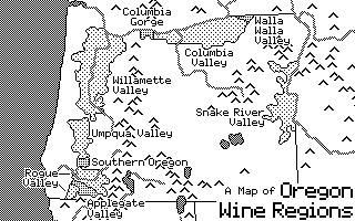
I have a friend who is very much into wine, and some way or another, the idea came up that I ought to do an Oregon Trail-style map of the various designated American Viticultural Areas of Oregon.


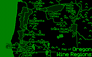
The image above was created at a size of 320 x 200. If you click, you can view a copy which I tripled to 960 x 600, so it was large enough to actually see. Pixels have gotten a lot smaller since the 80’s.
There is a group of five very small AVAs that are situated in the Willamette Valley, which I had to leave out due to size constraints. Suppose I’ll need to make a second map sometime.
It was a fun challenge to try and fit everything into such a small space and with no color to work with. I can’t say it’s wholly successful, but it was good enough for its purpose as an amusement. I have a mind to institute some sort of bitmap-mapping competition, but my last efforts at competition-sponsoring went poorly, so I may just skip it.
That’s all for the time being. I’m sure I’ll have more amusements in a few months.

Thanks for these. You can get around the Google search problem by putting “picturesque” in quotes.
Aha! Thanks for the tip.
>________________________________
Coincidentally, this just came across my news feeds:
“World’s Most Picturesque Villages” http://www.budgettravel.com/feature/worlds-most-beautiful-towns,8359/
There’s actually a ton you can do to help get better google search results. This infographic definitely helped educate me a few months ago.
http://www.howtogeek.com/98698/improve-your-google-search-skills-infographic/
Where did you get the AVA data? I was looking for that a while back, and completely failed to turn it up.
In the case of this map, I simply traced it from some of the maps I found inline, since my ability to trace was well within the range of accuracy afforded by the technique.
For other AVAs, though, I’ve pieced them together (somewhat painstakingly) using the definitions in the CFR (quick links here: http://www.iwineinstitute.com/avabystate.asp). I’ve built up shapefiles for most Midwestern ones, presently, for some work that a friend and I are hoping to do one day. But that’s been on the back burner for a while.
>________________________________
Yah, I was thinking of doing the same thing (actually started at one point), but tracing those DRGs sure is tedious…
I didn’t have to do too much tracing. I usually loaded in TIGER files for the roads, NHD for the rivers, etc, and then built the files out of those. I only had to trace a few times when, for example, the 1960s topo map that the CFR is referring to no longer matches modern shapefiles (a road rerouted, for example).
>________________________________
You should make prints of that mosaic and sell on Etsy or somewhere. I’d buy one!
This is disappointing, but not visually.
Sheffield is considerably less picturesque than the rest of Berkshire county, and Eastham (not pronounced “Eastem,” rather “East Ham”) less so than Welfleet and Truro.
I am glad, however, that Bing provided you with enough “picturesque” hits that Dennis is recognizable.
Woods Hole and the Islands clearly need better marketing, though. Perhaps I should contact the local chambers of commerce, and cite your work in a sales pitch.
In relation to the Choropleth map:
Just wondering how you used the original image colour to dictate the colours of the polygons. Did you make the average colour of the original image an attribute for each polygon area and then pull the polygon colour from this attribute?
If so, how, was this using QGIS?
Not quite, but there is some averaging involved.
For the dollar bill one, it was actually done a bit painstakingly by hand. In Photoshop I’d make a selection based on a layer with counties, then go to a layer below that with a dollar image, and run the Average filter using the selection shaped like the county.
I’ve also done it, much faster, in ArcMap, with zonal statistics. I used the counties as zones, and had it calculate the average for the raster using those zones. Had to do this separately for each channel, then recombine.
I’ve not used QGIS, so I can’t say how it works there, but I imagine a similar operation can be managed.
Hope this helps!